Many of us have lived for long enough to remember when the world was quite different… We can, if we try, use our imaginations and our memories to go back to earlier times.
Many of those memories can be triggered by things that we think we’ve forgotten, but can be reminded of – like the smell of the London Underground in the 1980s, or the taste of chips with newsprint still on them, or the feeling of non inertia-reel seatbelts, or the covering of ash that you got after the stubble was burned off the fields in the autumn.
Interestingly, many of us can go back further than our own lives. We’ve read enough history, and seen enough films that if we are reminded of things that pre-date us by a long way, we can begin to enter the period, and get a feel for how it looked, smelled, tasted, and felt … even though we don’t have a personal memory of it.
That’s what it’s like looking at old maps of London in the 19th century.
Today, I’ve been locating all the places that the AADD ran services and lectures, and it’s been fascinating to look around them, and see what was going on in the vicinity. It’s particularly interesting to peel back time using different maps (I have access to maps from the 1960s, back to the 1840s in some places) and see what changes.
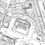
Take, for example, St Matthew’s school room on City Rd, which you can see just North of the church of St Matthews, marked as ‘national school’ on this 1870 map
Scan around the church, though, and as well as rows upon rows of houses, you find printing works, a rice mill, a hospital, a gas meter manufactory, a ‘Vulcanized India Rubber Works’, a coal depot, and a foundry, a canal, a paper staining works and a railway. (Today, I’ve also found a number of pickle factories, and a vinegar works – I can only imagine what they smelled like).
Populate the streets with people in Victorian dress, horses, carts, steam, noise, smell… and you start to get a feel for the kind of world that we’re exploring.

